RECCAD Reconstruction and Analysis of Complex Objects for Building CAD Models Based on Measured Data
by Václav Hlavác
The RECCAD project aim is to create a full geometric 3D model of a real existing object (eg a clay model created by a designer) automatically from several range images taken from different viewpoints. This joint research project supported by the European Union Copernicus action started in April 1995 and finishes in March 1998.Four research groups are involved in RECCAD. The project coordinator is Dr. Ralph Martin from University of Wales, College of Cardiff, Dept. of Computer Science, Cardiff, UK (ralph.martin@cs. cf.ac.uk). This partner expertise is namely in geometric modeling and computer vision. The second partner is from Hungarian Academy of Sciences, Institute for Computer Science and Automation, Budapest, Hungary. The team specializes in geometric modeling and is lead by Dr. Tamas Varady (varady@sztaki.hu). The third partner is University of Ljubljana, Faculty of Computer Science, Ljubljana, Slovenia. The partner's interest is accented in model-based vision using superquadrics, range images and its segmentation. Ljubljana team is headed by Prof. Franc Solina (franc. solina@fer.uni-lj.si). The last partner is Czech Technical University, Faculty of Electrical Engineering, Center for Machine Perception, headed by Prof. Václav Hlavá[. The Prague team is responsible within the project for range scanners, computing differential characteristics from range images, range image registration based on measured point clouds, image based scene representations.
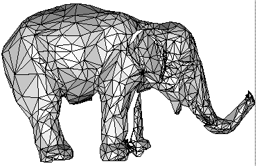
There are three streams within the RECCAD project towards creation of a full 3D CAD like model from measured free form object. In the first stream, the range data are segmented using a segmentation algorithm developed in Ljubljana using mainly superquadrics as primitives. These primitives are applied for registration and creation of the 3D model. In the second stream, the curves that correspond to natural division lines of the surface are found. The surface curvatures and other differential geometry based features are calculated from the range data. Registration uses these natural curves. Blends, as a way how industrial designers join smoothly surfaces, are of interest as well. In the third stream, we use point clouds only. The surface is densely triangulated on the rough measured data first. The number of triangles is decimated next, see illustration figure with the surface of a toy elephant. The data are than registered using the iterative closest point algorithm that is initiated either manually or based on the information about the viewpoint direction.
A toy elephant 3D model.The research results obtained up to now are quite promising and might be useful to industry and other research groups. Let us highlight some of them: one shot colour structure light range scanner (Prague), range image segmentor (Ljubljana), natural division lines of surfaces (Budapest, Cardiff, Prague), superquadrics based registration (Ljubljana), finding and using blends in model creation (Budapest, Cardiff), improvement of iterative closest point algorithm using reciprocal points (Prague), various ways of model creation (Cardiff, Budapest).
We aim at applying project results in industry. The intended applications at the moment are:
- rapid prototyping of clay models for Czech car manufacturer }koda
- prototyping for German car headlight company Hella
- measurement of the patient body shape for planning the irradiation treatment of the cancer.
Please contact:
Václav Hlavác - Czech Technical University
Tel: +420 2 24357465
E-mail: hlavac@vision.felk.cvut.cz