ICEMAP - Information to Ships in Winter Traffic
by Robin Berglund
ICEMAP is an application developed by VTT for interactive design of ice charts. It is in operational use at the Finnish, Swedish and German Ice Services, providing valuable information for winter traffic navigation.
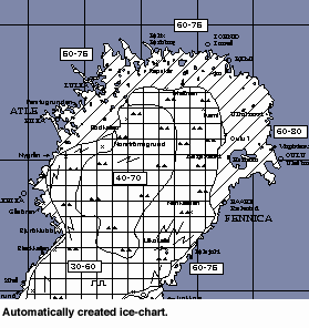
In wintertime the ice services in Finland, Sweden and Germany produce ice charts daily. The chart is drawn using international symbols showing ie different types of ice areas, their thickness, leads, cracks and also where the icebreakers are situated. Earlier the chart was drawn manually, then redrawn before being printed and sent to the ship owners, brokers, ships and authorities. In all there are hundreds of customers using the ice chart in each country. The value of the ice chart is determined by its accuracy and validity. The realtime aspect is important as the ice situation changes over time. ICEMAP speeds up the production of high quality charts that use remote sensing information.
Satellite images is the base for Ice charts
The ICEMAP is a UNIX-workstation based application that integrates the functions needed for interactive production of ice charts. Digitally stored satellite images from weather or radar satellites can be called up on the workstation, enhanced and used as basis for the drawing. The images are automatically remapped to the projection used in the ice chart (Mercator), if needed. Scaling and positioning of the image is also done automatically based on resolution and position information stored with the image header. Ground observations (temperature measurements) can easily be imported from a text file and used for automatic calculation of isotherms on open water regions.
Vector based drawing makes editing easier
ICEMAP is based on a polygon network philosophy, ie the areas representing different types of ice are polygons with shared borderlines. This facilitates editing of the chart and speeds up the production, because normally only part of the ice information has changed from one day to another. The user draws the borders between different types of ice. The areas are then determined by automatic identification of closed polygons defined by the user drawn borderlines and permanent coastlines. The ice areas can be individually selected and given a hatching according to the ice type of the area. When editing an area, the new borderline is drawn, then the old borderline is deleted.
Automatic send out to customers
The standard ice charting symbols can easily be added just by selecting the proper symbol from a toolbar and then placing the symbol by clicking on the ice chart. The complete ice chart is normally printed out on paper. By using conversion-routines, a high quality digitally generated telefax-version can be produced. The FAX-version enables automatic send out to regular customers or can be used in combination with a CallFax service for more widespread use. The ice chart information can also be output in a geocoded grid format. In this way sea surface temperature and ice property information can be utilized as input in local weather forecast models as well as for producing ice statistics for research purposes.
Please contact:
Robin Berglund - VTT
Tel: +358 9 456 6018
E-mail: Robin.Berglund@vtt.fi