Computing the Radiative Balance in Mountainous Areas: Modelling, Simulation and Visualization
by Jean-Luc Borel, Yves Durand, François Sillion and Christophe Le Gal
In mountain climatology and plant ecology, the estimation of the thermic action of the relief and the calculation of the radiative budget of the slopes constitute an inevitable prerequisite stage. Two image synthesis techniques have been used for the computation of the radiative balance in mountainous areas, namely the painter's algorithm and the radiosity model,. This approach allows to take into account, on a fine scale, the complexity of the interactions between the incident solar radiation (direct but also diffuse) on the one hand and and the local topography on the other hand.
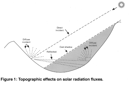
The research project presented hereunder is in keeping with the development of a high-resolution regional climate model. One of the main aims lies in the characterization and the quantification of the influence on the interface fluxes of the land surface properties, more especially those bound to the vegetation cover (albedo, roughness length, emissivity, evapotranspiration, ....). Nevertheless, in mountainous areas, altitude, aspect and slope greatly influence all the climatic parameters. Mountains, owing to the obstacle put to the solar radiation, may significantly modify the energy fluxes. Two problems have been tackled, first the impact on the direct solar radiation of the shadowing induced by a topographic mask effect and resulting in a so-called cast shadow, then the reflexion phenomena between opposite mountain sides, all particularly when the ground has a high albedo, for example when it is covered with snow (figure 1).
From a methodological point of view, noting that the distribution of light energy is one of the most frequently addressed problems in image synthesis, the exploration of the possibilities afforded by the techniques classically used in this scientific field has deliberately been chosen. This approach is therefore rather different from the topographically based solar radiation models already available. This research project has induced a transdisciplinary collaboration between a plant ecologist, a mountain climate specialist and an image synthesis specialist. The research work have been carried out in the frame of an university degree (DEA IVR, INPG-UJF, Grenoble) by a computing engineer during the last year.
The Cluses-Chamonix area, in the northern part of the French Western Alps (Haute Savoie) has been chosen as study area (55,5km x 20km). The spatial resolution of the digital elevation model (DEM) for this study area is 75m x 75m. Relating to the meteorological data, a data base has been set up for this study area with the output values of the SAFRAN analysis system, a numerical tool developed by the Centre d'Etudes de la Neige of Météo France. SAFRAN provides, since the 1st August 1981, an hourly estimation, above the ground surface, of the values of nine meteorological parameters for each 300m altitudinal section and for seven aspects; so, for example, concerning the incoming shortwave solar radiation, its two components : the direct incident solar radiation and the diffuse incident solar radiation. Considering the key role played by the snow on the distribution, composition and structure of the different vegetation communities in mountainous areas at mid and high altitudes, a physically-based snow cover simulation model has been developed. By another way, snow cover presents a high sensitivity to climate variations. This sensitivity to changes within the radiative budget has been used as to test the efficiency of the various algorithms selected. The computation of the radiative budget in each point of a mountain massif slope requires first at all to take into account the impact of the topographic masks and of the cast shadows induced by the surrounding relief on the direct incident solar radiation. The different available algorithms (ray tracing, ray casting, floating horizon, Z-buffer and painter's algorithm) have been systematically tested according to several criteria such as, for example, computer capacities, computing costs and display possibilities.
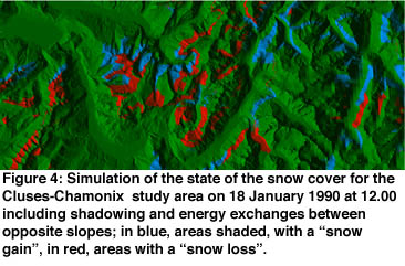
A preliminary study performed with a classical ray tracing method for a day chosen at random (9 March 1985) shows that the shadowing may cause a reduction of the received direct incident radiation ranging between 20 to 60 %! Now, owing to its small cost, the computation and the visualization of the interception by the surrounding relief of the direct incident solar radiation is performed with the so-called inverted version of the painter's algorithm. The painter's algorithm is a depth-sort algorithm which allows to display the polygons in order of the decreasing distance with regard to the observer, from back to front. After implementation of the inverted painter's algorithm (increasing distance from the viewpoint), a simulation of a yearly cycle, namely 1990, has been performed. It follows that the integration of the orographic effects in the computation of the radiative balance in mountainous regions may involve, in shaded areas, the appearance and/or the conservation of a snow cover. The impact of cast shadows on the space-time variability of the snow cover clearly appears at low and middle altitudes, their influence at high altitude remaining generally small. These consequences are illustrated by a simulation of the snow cover state for the Cluses-Chamonix study area on the 18 January 1990 at 12.00 (figure 2)
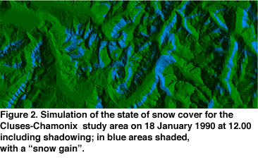
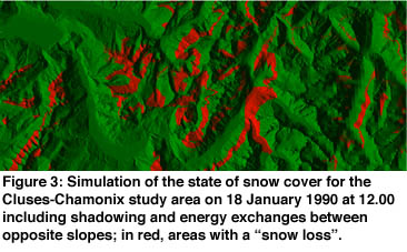
For the computation of the reflection phenomena between opposite mountain sides, the radiosity method has been used. The radiosity models are derived from the thermal models and are based on the notion of global energetic balance by taking into account the incident light energy, the scattered light energy and the absorbed light energy. They provide an accurate treatment of the light reflections between objects in a view-independent way. These algorithms are based on the conservation of the light energy in a closed environment. The use of the radiosity equation is based on the computing of the form factors between surfaces. The form factors may be defined as a coefficient of geometric coupling. In a first time, so as to estimate the possible energy exchanges, a simplified scale model of an encased valley chosen in the south-eastern part of the Cluses-Chamonix study area has been created. After computation of the form factors between the two opposite mountain slopes, the simulation shows that the taking into account of the energy exchange within mountain sides may increase the amount of the energy balance by about 40 % for ground without snow and even up to 150 % for a snow-covered ground ! The results of the simulation for the 18 January 1990 at 12.00 are shown in figure 3. At last, incidentally, the knowledge of the form factors and consequently of the visible sky proportion for each facet, the so-called sky-view factor, equally allows to evaluate the interception by the relief of the diffuse incident irradiance. The differences, positive and negative, involved by the integration of the relief effects on the computation of the radiative balance for the study area are summarized in the figure 4.
The main purpose of this research project was methodological. So as to assess as accurately as possible the impact of the topography on the radiative budget in mountainous areas, it seemed interesting to explore the possibilities afforded by the techniques used in image synthesis. It was then advisable to establish the relevance and to test the efficiency of the various proposed algorithms. The numerous simulations and visualizations performed for the Cluses-Chamonix study area with the digital elevation model and the snow model did not show obvious errors or inconsistencies. This preliminary research was a first stage of prime necessity. The short-term goal lies in the integration of the shadowing model in a high-resolution regional climate model so as to estimate more precisely the amount of direct irradiance for each surface location (pixel or groups of pixels) then, at middle term, the integration of the radiosity model for the calculation of the energy exchanges between opposite slopes. Simultaneously, complementary simulations will be performed so as to characterize the impact of the topography on the duration and on the intensity of the direct radiation fluxes according to the different aspects and according to many time scales (diurnal cycle, seasonal cycle, ....).
Please contact:
Jean-Luc Borel - Centre de Biologie Alpine, Université Joseph Fourier
Tel: +33 4 7663 5624
E-mail: borel@lamasig.ujf-grenoble.frYves Durand - Centre d'Etudes de la Neige, Météo France
Tel: +33 4 7663 7902
E-mail: durand@meteo.frFrançois Sillion - GRAVIR-IMAG
Tel: +33 4 7651 4354
E-mail: francois.sillion@imag.frChristophe Le Gal - GRAVIR-IMAG, INRIA Rhône-Alpes
Tel: +33 4 7661 5213
E-mail: christophe.le-gal@imag.fr