Image Processing for Forest Monitoring
by Josiane Zerubia and Paul-Henry Cournède
Aerial and satellite imagery have a key role to play in forestry management. The increasing availability of data and their high spatial resolution, which is now submetric, allow automatic tools to be developed that can analyse and monitor forests by accurately evaluating the vegetation resources. The Ariana research group at INRIA Sophia Antipolis, with its strong experience in remote-sensing image analysis and feature extraction, is working on this topic as part of the joint research effort 'Mode de Vie'.
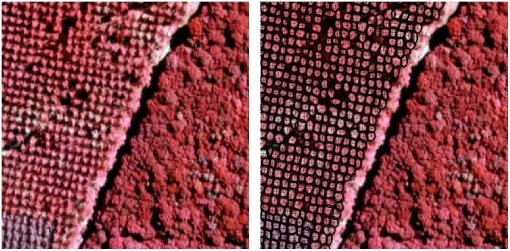
Digitized aerial photographs and satellite images of forests represent convenient data for developing computerized assessments of forestry resources. Such automatic tools are useful for a number of reasons, including the help with which they provide forest managers in classifying species. Such work is currently done by specialists, using difficult image analysis combined with ground verifications. Some tools already exist for this purpose, and use texture information and classification based on parameters such as covariance matrices. However, few take advantage of high data resolution. Nowadays, it is possible to study forests on the scale of individual trees, by resolving the extraction of tree crowns. This is one of the aims of the Ariana research group, which in the last year has adapted its knowledge in stochastic geometry (object processes) to forest-resource evaluation. This will allow the automatic assessment of economically and environmentally important parameters such as the number of tree crowns, the distribution of their diameters or the stem density.
Our approach consists in modelling the forestry images as realizations of a marked point process of trees. This stochastic framework aims at finding the best configuration of an unknown number of geometrical objects in the image, with respect to a probability density defined a priori. This density takes into account both the data, in order to fit the objects to the feature we want to extract, and the interactions between these objects, to favour or penalize some arrangements. In the case of tree-crown extraction, we modelled the trees as ellipses, defined by the position of their centre, their orientation, and their major and minor axes. After simulation, we obtain a collection of objects and have access to several statistics such as the number of trees in the stand, their position and their diameter. If different species coexist, we can add a mark to the objects to describe their type, and obtain a classification during the extraction. Some tests have been performed on digitized aerial photographs of stands of poplars, courtesy of the French Forest Inventory (IFN). These photographs are taken in the infrared, which enhances the chlorophyll matter of vegetation. In future investigations, we will be studying texture parameters in order to distinguish different species during the simulation, and lower-level information to obtain a pre-segmentation of the image before the extraction process.
Another application relevant to forest monitoring has been developed by Ariana in collaboration with Alcatel Space, and addresses forest-fire detection on satellite images, using the random fields theory. It consists in modelling the image as a realization of a Gaussian field, in order to extract rare events like potential fires that could grow and imply serious damage. For this purpose, the thermal infrared channel (TIR) is selected, since fires show up as peaks of intensity at these wavelengths.
Of further interest is the involvement of Ariana in the ARC joint research effort Mode de Vie, in collaboration with MAS Laboratory (Ecole Centrale Paris), the Digiplante research group (INRIA Rocquencourt, CIRAD), and LIAMA (Sino-French Laboratory of Informatics and Automation, Academy of Sciences, Beijing, China). The purpose of this joint action is to link the assessment of forestry resources with the dynamical models of plant growth developed in Digiplante and LIAMA. The ultimate target would be to develop a complete tool for vegetation monitoring, which could both evaluate the present biomass and predict its evolution.
Links:
http://www.inria.fr/ariana
http://www.inria.fr/recherche/equipes/digiplante.en.html
http://www.mas.ecp.fr
http://liama.ia.ac.cn
Please contact:
Josiane Zerubia, INRIA, France
Tel: +33 4 9238 7865
E-mail: Josiane.Zerubia inria.fr
Paul-Henry Cournède, MAS - Ecole Centrale Paris, France
Tel: +33 1 4113 1289
E-mail: Paul-Henry.Cournedemas.ecp.fr